The Greenwich Meridian
…where east meets west
Visiting the Meridian Marks
Finding the marks
Printer friendly pages showing location details, a picture of the mark and a detailed location map can be printed directly from the web site.
Getting there
If travelling by car, bear in mind that the nearest safe parking may be several miles from the mark you wish to visit. This is as true of roadside markings as it is of those on footpaths and in the more remote locations. In towns and cities, where markings are in close proximity, the quickest way of getting about is usually on foot.
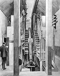 The Airy Transit Circle and the Royal Observatory
The Royal Observatory, Greenwich is part of the National Maritime Museum. It is recommended that you consult the Museum’s website (link below) for the latest visitor information before you arrange your visit. An admission charge is payable.
Useful aids
This section should be read in conjunction with the pages (left) on Coordinate Systems, WGS84 and the Greenwich Meridian and The Greenwich Meridian before the ATC.
GPS can be a real help in locating the Line, but the receiver needs to be set to an appropriate Datum and where necessary an offset applied. The receiver can be set to show the direction of travel, but unless it has an inbuilt electronic compass, will only be able to do so while it is moving. For this reason, a magnetic compass may also be useful.
 In the UK, the OS 1:25,000 (Explorer) and 1:50,000 (Landranger) maps are probably the most practical, but both have their drawbacks. None of the current editions have the position of the Meridian marked. However, it was marked on the special edition of Explorer maps produced for the Millennium. Now out of print, used copies occasionally come up for sale on e-bay and through Internet booksellers.
The approximate position of the Bradley Meridian can be drawn on the Landranger maps by making use of the longitude scale marked along the top and the bottom of the sheet, together with the graticules (small blue upright crosses) that are marked every 5' of latitude and longitude (as space permits) within the body of the map. When correctly drawn, the Meridian will curve slightly and slope from right to left as it runs up the page. The Explorer maps have the longitude scales, but lack the graticules. When connected by a single straight line, the error will be no greater than about 50 m at the centre of the map.
The route of the Meridian is covered by 17 Explorer maps: 122, 135, 146, 161, 162, 174, 194, 209, 225, 227, 235, 249, 261, 273, 282, 283 and 292. Of these, map 282 can be omitted as the section of the Line it covers, is also covered by map 283. For complete coverage with the Landranger series, 10 maps are required: 198, 187, 177, 166, 154, 142, 131, 122, 113 and 107.
Google Earth (link below) can be set to show the WGS84 latitude and longitude grid – an invaluable aid if you want to follow the WGS84 Meridian, but less useful for the Airy or Bradley Meridian.
Links
Royal Observatory, Greenwich (part of the National Maritime Museum)Google Earth
Ordnance Survey mapping projection