The Greenwich Meridian
…where east meets west
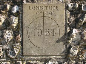
| Location | England East Sussex Iford |
| S side of: unnamed road (outside Village Hall) | |
| Distance (S) from Greenwich | |
| OS map details | OS Explorer: 122 |
| OS grid ref | TQ 40786.07307 (540786,107307) |
| WGS84 lat/long | 50.848160, -0.001499 |
| Type | Plaque (wall) |
| Marking date | 1984 |
| Access | Unrestricted |