The Greenwich Meridian
…where east meets west
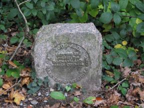
| Location | England Surrey Dormansland |
| W side of: Mill Lane | |
| Distance (S) from Greenwich | |
| OS map details | OS Explorer: 146 |
| OS grid ref | TQ 39835.41632 (539835,141632) |
| WGS84 lat/long | 51.156862, -0.001789 |
| Type | Marker 'stone' |
| Marking date | 2000 |
| Access | Unrestricted |