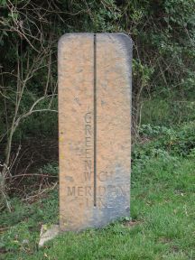
The Greenwich Meridian
…where east meets west
| Location | England Cambridgeshire Needingworth & Holywell |
| E side of: Ouse Valley Way (footpath) | |
| Distance (N) from Greenwich | |
| OS map details | OS Explorer: 225 |
| OS grid ref | TL 36293.71884 (536293,271884) |
| WGS84 lat/long | 52.328129, -0.001409 |
| Type | Marker 'stone' |
| Marking date | 2000 |
| Access | Unrestricted |